
Story
The Iliad project builds on the assets resulting from two decades of investments in policies and infrastructures for the blue economy and aims at establishing an interoperable, data-intensive, and cost-effective Digital Twin of the Ocean (DTO).
It capitalises on the explosion of new data provided by many different earth sources, advanced computing infrastructures (cloud computing, High Performance Computing, Internet of Things, Big Data, social networking, and more) in an inclusive, virtual/augmented, and engaging fashion to address all Earth Data challenges.
The enabling technology of the ILIAD DTO will contribute to the implementation of the EU’s Green Deal and Digital Strategy and to the achievement of the UN Ocean Decade‘s outcomes and Sustainable Development Goals.
It will contribute towards a sustainable ocean economy as defined by the Centre for the Fourth Industrial Revolution and the Ocean, a hub for global, multi-stakeholder co-operation.
The Iliad DTOs will fuse a large volume of diverse data, in a semantically rich and data-agnostic approach to enable simultaneous communication with real world systems and models. Ontologies and a standard style-layered descriptor will facilitate semantic information and intuitive discovery of underlying information and knowledge to provide a seamless experience. The combination of geo visualisation, immersive visualisation and virtual or augmented reality allows users to explore, synthesise, present, and analyse the underlying geospatial data in an interactive manner.
The enabling technology of the Iliad DTOs will contribute to the implementation of the EU’s Green Deal and Digital Strategy and to the achievement of the UN Ocean Decade’s outcomes and Sustainable Development Goals. To realise its potential, Iliad DTOs will follow the System of Systems approach, integrating all existing EU Earth Observing and Modelling Digital Infrastructures and Facilities to promote additional applications through Iliad DTOs, the partners created the Iliad Marketplace. Like an app store, providers will use the Iliad Marketplace to distribute apps, plug-ins, interfaces, raw data, citizen science data, synthesised information, and value-adding services derived from the Iliad DTOs.
Process
Results
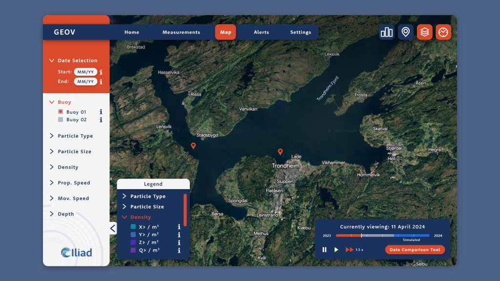
Within the scope and applications ecosystem of ILIAD, we allow the representation of particles in water in 2D and 3D, with the possibility of controlling the flow of time of the visualisation. By providing the propagation data of your particles (we currently adhere to NetCDF files output of OpenDrift, providing Latitude, Longitude, Depth, Diameter, and Categorization of the particles in time-series), you will be able to visualise the simulation of your particles and control the time flow.
The GeoViz application has been developed using the Unity game engine.
The global visualisation is provided using the Cesium Ion plugin for Unity.
More details about the resolution of the bathymetrical visualisation.
Parsing information from NetCDF to C# data structures is possible through the use of the Microsoft Scientific DataSet library for .NET.
The primary scope of the application was to provide visualisation for an Iliad’s pilot owning microparticles’ data as time-series, but at release, the codebase will be made available to the public, allowing anyone to clone the GitHub repository and develop their own parser fitting their data.
The use of the codebase of the application will be regulated by the license available in the repository.
In case your dataset does not work as-is with the GeoViz (you load the dataset file into GeoViz but see no particles), then you should validate your dataset with the GeoViz Data Tool, made publicly available here.
Technical Details
Research Output
Full List of Partners
www.ocean-twin.eu/partners
